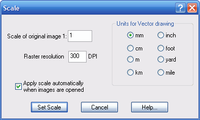
The Scale function is available on the Vector menu, or by pressing the F8 keyboard button.
The Scale feature is very useful for specifying the size of the vector output drawing, where the Georeference feature is not required.
Raster files generally do not contain information about the real size of the image that they represent. This is why WinTopo defaults the drawing scale to 1 pixel = 1 drawing unit.
However, in most cases this default size is not what is required.
The Scale feature can be used to ensure that the drawing is the size and scale that you want. The Scale window contains the following options:
Scale of original image 1:
Often the raster image is scanned from a paper drawing that was drawn to a particular scale. For example, a map might be drawn at a scale of 1:25000, or a building schematic might be drawn at a scale of 1:100.
The original drawing scale can be entered here so that WinTopo can adjust the output drawing to measure correctly for your drawing units.
If your original image was already at the correct size, then you should enter 1 for this value.
Raster resolution
Most raster files include the image resolution. If this is the case, WinTopo will automatically display the correct resolution here. The resolution is measured in Dots Per Inch (DPI).
If the raster file does not include its resolution then WinTopo will assume the same resolution as the previous image. If you know the image resolution to be different from that shown then you can enter it here.
WinTopo needs to know the correct image resolution in order to output the vector drawing to the correct scale.
Units for drawing
There are a choice of common drawing units in both metric and imperial measures. You should select the drawing units that you want to use on the output vector drawing. WinTopo will then scale the drawing appropriately.
Apply scale automatically
If you find the Scale feature useful, then you will probably want to select this option so that the scale is applied automatically for each image that you open, without you having to select the Scale feature each time.
For example, if the images that you process are all the same scale, and you always use the same drawing units.
When each image is opened WinTopo will try to determine the DPI. If the DPI is not given in the raster file then WinTopo will use the same DPI as the previous image.
WinTopo will use your settings of image scale and drawing units that are set on this window, and the scale is applied as soon as each raster is opened.
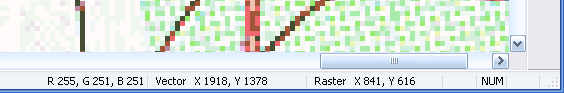
After the Set Scale button is clicked WinTopo will apply the appropriate scaling to the vector drawing. You can see the vector coordinates on the status bar at the bottom of the WinTopo window, which track the mouse movement.
If you subsequently use the Georeference feature to set control points, then they will override the scaling from this function.
If you have previously used the Georeference feature to set control points, then this scaling function will disable those control points.